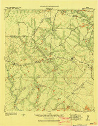
1920 Map of Smiley
USGS Topo · Published 1920About this map
The Guadalupe River and its numerous tributaries, including Cibolo Creek and Ecleto Creek, define the landscape of this South Texas region where multiple county lines converge. Based on surveys from 1908, the area shows a transition from cattle ranching to a railroad-driven economy, anchored by the Southern Pacific Railroad System which connects centers like Stockdale, Nixon, and Smiley. Smaller rural settlements such as Dewville and Nopal reflect the sparse population outside the primary rail hubs.
Find a feature on this map
83 named features on this map. Tap any name to fly to it.
Don’t see what you’re looking for? This feature index may not catch every label — zoom into the map to look around manually.
Map Details
Editions of this 1920 Smiley Map
This is the sole edition of this map. No revisions or reprints were ever made.
Historical Maps of Nixon Through Time
3 maps found