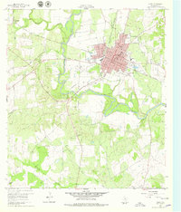
1960 Map of Cuero
USGS Topo · Published 1979About this map
The city of Cuero sits as a regional hub in DeWitt County, anchored by its grid of streets such as Esplanade Street and Broadway St. The Guadalupe River meanders to the west, defining the local topography alongside its many tributaries including Sandies Creek and Threemile Creek. Evidence of early 20th-century transportation is visible in the Old Railroad Grade and the active tracks of the Texas and New Orleans railroad, which historically served as the Southern Pacific line. Beyond the urban center, the map documents the rural infrastructure of the era, from the Ratcliffe Sch in the southwest to the Antioch Ch and Zion Ch. Notable community landmarks such as Burns Hospital and the Municipal Airport contrast with industrial features like several Gravel Pits and the local Sewage Disposal plant.
Find a feature on this map
50 named features on this map. Tap any name to fly to it.
Don’t see what you’re looking for? This feature index may not catch every label — zoom into the map to look around manually.
Map Details
Editions of this 1960 Cuero Map
Other maps of this area

1953 · Beeville
USGS Topo · 1:250,000

1953 · Seguin
USGS Topo · 1:250,000

1956 · Beeville
USGS Topo · 1:250,000

1958 · Seguin
USGS Topo · 1:250,000

1960 · Beeville
USGS Topo · 1:250,000

1960 · Cuero
USGS Topo · 1:24,000

1960 · Concrete
USGS Topo · 1:24,000

1960 · Blackwell Lake
USGS Topo · 1:24,000

1960 · Westhoff
USGS Topo · 1:24,000

1962 · Verhelle
USGS Topo · 1:24,000