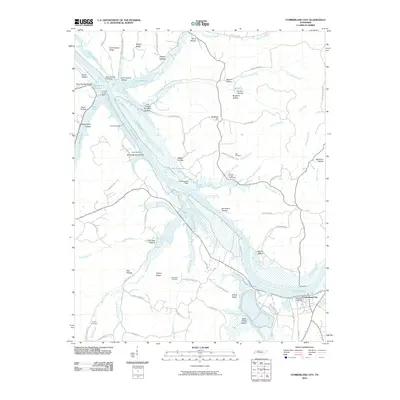
2010 Map of Cumberland City
USGS Topo · Published 2010About this map
Lake Barkley dominates the central corridor of this Stewart County landscape, where the inundated valley is regulated by engineering works like the Pool Five Dam, Pool Six Dam, and Pool Fourteen Dam. The town of Cumberland City sits at the southeastern bend of the river, anchored by McCartys Landing and the mouth of Wells Creek. This area preserves a high density of family-named topography and local landmarks, from Brigham Hill to the numerous hollows that define the western bank, such as Potatopatch Hollow and Skunk Hollow. Genealogists will find several burial sites recorded across the terrain, including Haus Cemetery, Dunbar Chapel Cemetery, and the John Brake Cemetery near Traylor Ridge. The map details a transition from the managed waters of the Cross-Creek Reservoir to the ridges like Commissary Ridge that overlook the river valley.
Find a feature on this map
80 named features on this map. Tap any name to fly to it.
Don’t see what you’re looking for? This feature index may not catch every label — zoom into the map to look around manually.
Map Details
Editions of this 2010 Cumberland City Map
This is the sole edition of this map. No revisions or reprints were ever made.
Other maps of this area

1931 · Erin
USGS Topo · 1:62,500

1936 · Tantrough Hollow
USGS Topo · 1:24,000

1936 · Stewart
USGS Topo · 1:24,000

1936 · Dover
USGS Topo · 1:24,000

1950 · Stewart
USGS Topo · 1:24,000

1950 · Dover
USGS Topo · 1:24,000

1951 · Indian Mound
USGS Topo · 1:24,000

1951 · Bumpus Mills
USGS Topo · 1:24,000

1951 · Woodlawn
USGS Topo · 1:24,000

1956 · Nashville
USGS Topo · 1:250,000