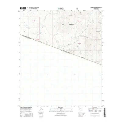
2014 Map of Cumero Mountain
USGS Topo · Published 2014About this map
Coronado National Forest dominates the upper half of this 2014 survey, where the rugged southern Arizona landscape meets the international boundary line with Mexico. The terrain is defined by the San Luis Mountains and prominent peaks like Cumero Mountain and Lesna Peak. Industrial and water-management features are scattered throughout this arid environment, most notably the Sandwash Mill and a series of livestock tanks such as Slick Rock Tank, Alamito Tank, and the curiously named Marijuana Tank. Below the border, the topography levels into a grid, while the northern portion remains a network of ephemeral drainages like Arrieta Wash and deep cuts like Coches Canyon. This map provides a clear record of the ranching and milling infrastructure existing along the Pima Co border in the early 21st century.
Find a feature on this map
27 named features on this map. Tap any name to fly to it.
Don’t see what you’re looking for? This feature index may not catch every label — zoom into the map to look around manually.
Map Details
Editions of this 2014 Cumero Mountain Map
This is the sole edition of this map. No revisions or reprints were ever made.
Other maps of this area

1920 · Arivaca
USGS Topo · 1:125,000

1921 · Old Glory
USGS Topo · 1:125,000

1941 · Presumido Peak
USGS Topo · 1:62,500

1941 · Arivaca
USGS Topo · 1:62,500

1942 · Oro Blanco
USGS Topo · 1:62,500

1943 · Fresnal
USGS Topo · 1:125,000

1943 · Arivaca
USGS Topo · 1:62,500

1943 · Old Glory
USGS Topo · 1:125,000

1943 · Presumido Peak
USGS Topo · 1:62,500

1944 · Oro Blanco
USGS Topo · 1:62,500