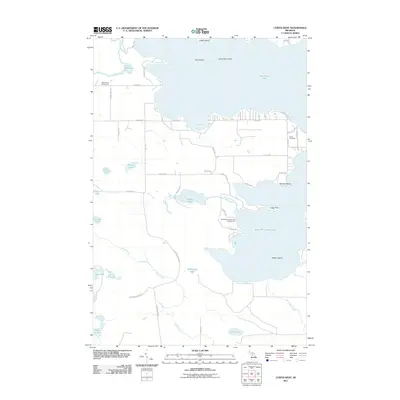
2011 Map of Curtis West
USGS Topo · Published 2011About this map
Manistique Lake and South Manistique Lake dominate this portion of Mackinac County, connected by a network of waterways and wetlands that includes the Shoepac River and Wolf Creek. The landscape is a mix of recreational shoreline and timber-harvesting history, evidenced by the presence of the Old Bryan Grade Rd, a reminder of the region's logging rail infrastructure. Local community landmarks such as Curtis Cemetery and the Blue Heron Golf Course are situated near the northern lake's edge, while the South Manistique Lake Campground serves visitors at the narrowest point of the southern lake. Islands like Gull Island and Norton Island punctuate the large open waters, highlighting the glacial topography of Michigan's Upper Peninsula. This 2011 survey captures the area's transition into a modern recreational destination while preserving the footprints of its industrial past.
Find a feature on this map
52 named features on this map. Tap any name to fly to it.
Don’t see what you’re looking for? This feature index may not catch every label — zoom into the map to look around manually.
Map Details
Editions of this 2011 Curtis West Map
This is the sole edition of this map. No revisions or reprints were ever made.
Other maps of this area

1931 · Seney SW
USGS Topo · 1:31,680

1931 · Gould City NW
USGS Topo · 1:31,680

1931 · Blaney SW
USGS Topo · 1:31,680

1931 · Seney SE
USGS Topo · 1:31,680

1931 · Blaney NE
USGS Topo · 1:31,680

1931 · Blaney SE
USGS Topo · 1:31,680

1931 · Blaney NW
USGS Topo · 1:31,680

1954 · Sault Sainte Marie
USGS Topo · 1:250,000

1956 · Sault Sainte Marie
USGS Topo · 1:250,000

1957 · Sault Sainte Marie
USGS Topo · 1:250,000
Featured Places
- Newton Township, MI
- Germfask Township, MI
- Portage Township, MI
- Mueller Township, MI
- Lakefield Township, MI