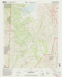
1997 Map of Cuyamaca Peak
USGS Topo · Published 2000About this map
Cuyamaca Rancho State Park and the surrounding Cleveland National Forest dominate this late-century landscape, capturing the area's transition into a major recreational and conservation hub. The map centers on the high elevations of the Cuyamaca Mountains, including Middle Peak, Stonewall Peak, and the namesake Cuyamaca Peak. Evidence of the region's earlier industrial roots remains visible at the Stonewall Mine and Museum near the shores of Cuyamaca Lake, which is regulated by the Cuyamaca Dam.
Find a feature on this map
59 named features on this map. Tap any name to fly to it.
Don’t see what you’re looking for? This feature index may not catch every label — zoom into the map to look around manually.
Map Details
Editions of this 1997 Cuyamaca Peak Map
This is the sole edition of this map. No revisions or reprints were ever made.
Other maps of this area

1903 · Cuyamaca
USGS Topo · 1:125,000

1903 · Ramona
USGS Topo · 1:125,000

1904 · Southern California Sheet No. 2
USGS Topo · 1:250,000

1931 · Vallecito
USGS Topo · 1:125,000

1931 · Carrizo
USGS Topo · 1:125,000

1939 · Santa Ysabel
USGS Topo · 1:62,500

1939 · Borrego
USGS Topo · 1:62,500

1942 · Borego
USGS Topo · 1:62,500

1942 · Cuyapaipe
USGS Topo · 1:62,500

1942 · Cuyamaca Peak
USGS Topo · 1:62,500