2022 Map of Dacoma
USGS Topo · Published 2022About this map
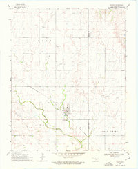
Dacoma serves as the central hub of this prairie landscape, situated near the boundary between Woods Co and Alfalfa Co. The town's grid is anchored by Broadway St, which is surrounded by early numbered streets like 6th St and 15th St. This area reflects the organized land division of the Public Land Survey System, with a network of rural roads such as Grant Rd and Custer Rd connecting isolated farmsteads and agricultural plots. The hydrology is defined by the winding paths of Eagle Chief Creek and Lake Creek, which provide natural relief to the otherwise rigid section lines. Genealogists will find interest in localized burial sites, including the Union Center Cemetery to the north and the Garrison Cemetery to the east, which suggest the placement of long-standing community congregations outside the main township.
Find a feature on this map
28 named features on this map. Tap any name to fly to it.
Don’t see what you’re looking for? This feature index may not catch every label — zoom into the map to look around manually.
Map Details
Editions of this 2022 Dacoma Map
This is the sole edition of this map. No revisions or reprints were ever made.