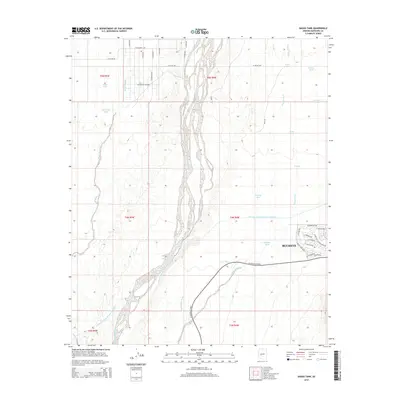
2014 Map of Daggs Tank
USGS Topo · Published 2014About this map
The Hassayampa River channel dominates this desert landscape, its wide, braided course trending southward through the center of the terrain. To the west, the arid basins are marked by water management features like Daggs Tank and New Daggs Tank, which gather runoff from the surrounding slopes. The Central Arizona Project Aqueduct cuts a distinct industrial line across the lower half of the map, illustrating the massive engineering efforts required to move water through the Arizona desert. On the eastern edge, the expanding residential footprint of Buckeye is visible, with a burgeoning street grid including W Beardsley Pky and W Tonopah Dr signaling modern suburban growth. This intersection of natural washes, such as Wagner Wash and Bootlegger Wash, with human-made infrastructure like W Sun Valley Pkwy defines the contemporary transition of the desert into a managed landscape.
Find a feature on this map
34 named features on this map. Tap any name to fly to it.
Don’t see what you’re looking for? This feature index may not catch every label — zoom into the map to look around manually.
Map Details
Editions of this 2014 Daggs Tank Map
This is the sole edition of this map. No revisions or reprints were ever made.
Other maps of this area

1954 · Phoenix
USGS Topo · 1:250,000

1957 · Phoenix
USGS Topo · 1:250,000

1957 · White Tank Mts. SE
USGS Topo · 1:24,000

1957 · White Tank Mts. NE
USGS Topo · 1:24,000

1957 · White Tank Mts.
USGS Topo · 1:62,500

1958 · Phoenix
USGS Topo · 1:250,000

1960 · Phoenix
USGS Topo · 1:250,000

1961 · Vulture Mountains
USGS Topo · 1:62,500

1962 · Belmont Mts
USGS Topo · 1:62,500
1965 · Wittmann
USGS Topo · 1:24,000