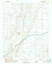
1988 Map of Daggs Tank
USGS Topo · Published 1988About this map
Hassayampa Plain dominates the western portion of this desert landscape, where water management is the primary driver of development in the late twentieth century. The Hassayampa River and Daggs Wash course through the arid terrain, supported by an extensive network of human-made catchments including Daggs Tank, New Daggs Tank, and Roosevelt Tank. The arrival of the massive Granite Reef Aqueduct signifies a major shift in regional infrastructure, complete with a dedicated Pumping Station and Substation to move water across the valley.
Find a feature on this map
36 named features on this map. Tap any name to fly to it.
Don’t see what you’re looking for? This feature index may not catch every label — zoom into the map to look around manually.
Map Details
Editions of this 1988 Daggs Tank Map
This is the sole edition of this map. No revisions or reprints were ever made.
Other maps of this area

1954 · Phoenix
USGS Topo · 1:250,000

1957 · Phoenix
USGS Topo · 1:250,000

1957 · White Tank Mts. SE
USGS Topo · 1:24,000

1957 · White Tank Mts. NE
USGS Topo · 1:24,000

1957 · White Tank Mts.
USGS Topo · 1:62,500

1958 · Phoenix
USGS Topo · 1:250,000

1960 · Phoenix
USGS Topo · 1:250,000

1961 · Vulture Mountains
USGS Topo · 1:62,500

1962 · Belmont Mts
USGS Topo · 1:62,500
1965 · Wittmann
USGS Topo · 1:24,000