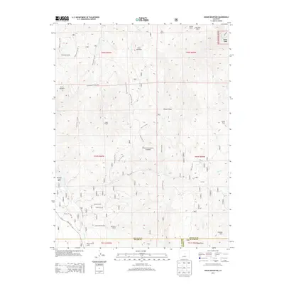
2013 Map of Dakan Mountain
USGS Topo · Published 2013About this map
Pike National Forest dominates this mountain landscape, which straddles the borders of Douglas, Teller, and El Paso counties. The map traces a complex network of forest trails and gulches, including Indian Cave Trail 705 and the various branches of the Fern Trail system. High points like Dakan Mountain and Storm Peak define the topography of the Rampart Range, while the eastern edge reveals the edge of residential development at Perry Park. The intricate drainage patterns of Illinois Gulch and Missouri Gulch illustrate the deep erosion of the Front Range foothills. To the west, State Hwy 67 cuts through the terrain near Rainbow Falls Park, providing access to the more remote interior valleys like Long Hollow and the Trout Creek basin.
Find a feature on this map
51 named features on this map. Tap any name to fly to it.
Don’t see what you’re looking for? This feature index may not catch every label — zoom into the map to look around manually.
Map Details
Editions of this 2013 Dakan Mountain Map
This is the sole edition of this map. No revisions or reprints were ever made.
Other maps of this area

1893 · Platte Canyon
USGS Topo · 1:125,000

1894 · Castle Rock
USGS Topo · 1:125,000

1913 · Castle Rock
USGS Topo · 1:125,000

1940 · Castle Rock
USGS Topo · 1:62,500

1945 · Castle Rock
USGS Topo · 1:62,500

1953 · Denver
USGS Topo · 1:250,000

1954 · Devils Head
USGS Topo · 1:24,000

1954 · Deckers
USGS Topo · 1:24,000

1954 · Mount Deception
USGS Topo · 1:24,000
1954 · Palmer Lake
USGS Topo · 1:24,000