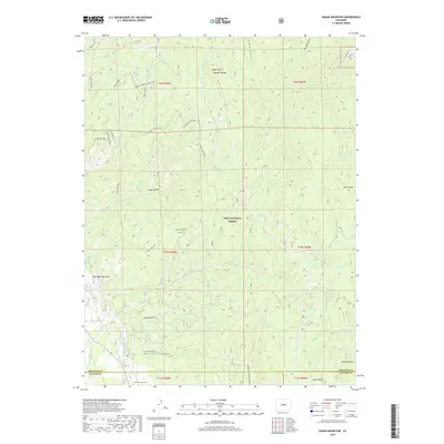
2019 Map of Dakan Mountain
USGS Topo · Published 2019About this map
Pike National Forest dominates this section of the Rampart Range, where the landscape is defined by a complex network of drainages and peaks. The topography is anchored by Dakan Mountain and Turtle Mountain, with numerous narrow ravines such as Illinois Gulch, Missouri Gulch, and White Spruce Gulch carving through the high ground. A notable cultural landmark, Indian Cave, is situated in the southwestern portion of the quadrangle near the boundary between Douglas and Teller counties.
Find a feature on this map
36 named features on this map. Tap any name to fly to it.
Don’t see what you’re looking for? This feature index may not catch every label — zoom into the map to look around manually.
Map Details
Editions of this 2019 Dakan Mountain Map
This is the sole edition of this map. No revisions or reprints were ever made.
Other maps of this area

1893 · Platte Canyon
USGS Topo · 1:125,000

1894 · Castle Rock
USGS Topo · 1:125,000

1913 · Castle Rock
USGS Topo · 1:125,000

1940 · Castle Rock
USGS Topo · 1:62,500

1945 · Castle Rock
USGS Topo · 1:62,500

1953 · Denver
USGS Topo · 1:250,000

1954 · Devils Head
USGS Topo · 1:24,000

1954 · Deckers
USGS Topo · 1:24,000

1954 · Mount Deception
USGS Topo · 1:24,000
1954 · Palmer Lake
USGS Topo · 1:24,000