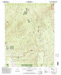
1994 Map of Dakan Mountain
USGS Topo · Published 1998About this map
The Manitou Experimental Forest dominates the southern reaches of this landscape, where researchers and foresters managed the complex ecosystem of the Rampart Range Road corridor. In the northern sections, the Pike National Forest encompasses prominent summits such as Dakan Mountain and Turtle Mountain. The map reveals a land defined by water and elevation, with the South Platte River and its numerous tributaries, including Jackson Creek and Illinois Gulch, carving through the Platte River Mountains. A distinct Quarry near the experimental forest boundary points to the area's geological utility, while Saylor Park provides a notable clearing amidst the timbered peaks. This mid-1990s revision captures the area's dual role as a site for both industrial extraction and large-scale silvicultural study.
Find a feature on this map
29 named features on this map. Tap any name to fly to it.
Don’t see what you’re looking for? This feature index may not catch every label — zoom into the map to look around manually.
Map Details
Editions of this 1994 Dakan Mountain Map
This is the sole edition of this map. No revisions or reprints were ever made.
Other maps of this area

1893 · Platte Canyon
USGS Topo · 1:125,000

1894 · Castle Rock
USGS Topo · 1:125,000

1913 · Castle Rock
USGS Topo · 1:125,000

1940 · Castle Rock
USGS Topo · 1:62,500

1945 · Castle Rock
USGS Topo · 1:62,500

1953 · Denver
USGS Topo · 1:250,000

1954 · Devils Head
USGS Topo · 1:24,000

1954 · Deckers
USGS Topo · 1:24,000

1954 · Mount Deception
USGS Topo · 1:24,000
1954 · Palmer Lake
USGS Topo · 1:24,000