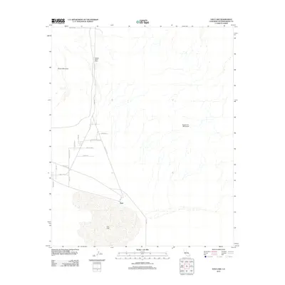
2012 Map of Dale Lake
USGS Topo · Published 2012About this map
Dale Lake anchors this arid San Bernardino County landscape, situated at the southern terminus of a network of desert roads and trails. The map documents the isolated settlement of Bush, positioned where Ironage Rd and Amboy Rd converge near the playa's edge. The terrain is defined by the massive presence of the Sheep Hole Mountains to the east and the Bullion Mountains to the west, separated by the strategic Sheep Hole Pass.
Find a feature on this map
21 named features on this map. Tap any name to fly to it.
Don’t see what you’re looking for? This feature index may not catch every label — zoom into the map to look around manually.
Map Details
Editions of this 2012 Dale Lake Map
This is the sole edition of this map. No revisions or reprints were ever made.
Other maps of this area

1942 · Amboy
USGS Topo · 1:250,000

1943 · Amboy
USGS Topo · 1:250,000

1954 · Needles
USGS Topo · 1:250,000

1954 · Bristol Lake SW
USGS Topo · 1:24,000
1955 · Cleghorn Lakes
USGS Topo · 1:24,000

1955 · Lead Mountain
USGS Topo · 1:62,500

1956 · Needles
USGS Topo · 1:250,000

1956 · Dale Lake
USGS Topo · 1:62,500

1956 · Bristol Lake
USGS Topo · 1:62,500
1956 · Valley Mountain
USGS Topo · 1:62,500