
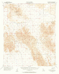
1955 Map of Lead Mountain
USGS Topo · Published 1959About this map
The Bullion Mountains dominate this mid-century desert landscape, where mineral extraction and military training intersect. Surveyed during the mid-1950s, the terrain is marked by significant mining sites including the War Eagle Mine and the American Mine, alongside various Prospects scattered through the north. This period captures the region as it was integrated into the Marine Corps Naval Reservation, a transition that reshaped land use in this part of the Mojave. The arid environment is defined by its seasonal hydrology, featuring the expansive Bristol Lake, the Dry Lake to the north, and the isolated Cleghorn Lakes in the south. High points such as Lead Mountain and Bullion East provide topographic anchors for a region where water sources like Dry Well were critical for those navigating the Cleghorn Pass.
Find a feature on this map
15 named features on this map. Tap any name to fly to it.
Don’t see what you’re looking for? This feature index may not catch every label — zoom into the map to look around manually.
Map Details
Editions of this 1955 Lead Mountain Map
2 editions found
Other maps of this area

1942 · Amboy
USGS Topo · 1:250,000

1943 · Amboy
USGS Topo · 1:250,000

1953 · San Bernardino
USGS Topo · 1:250,000

1954 · Needles
USGS Topo · 1:250,000

1954 · Bristol Lake NW
USGS Topo · 1:24,000

1954 · Amboy Crater
USGS Topo · 1:24,000

1954 · Bagdad SW
USGS Topo · 1:24,000

1954 · Bristol Lake SW
USGS Topo · 1:24,000

1954 · Ludlow SE
USGS Topo · 1:24,000

1954 · Valley Mtn
USGS Topo · 1:24,000