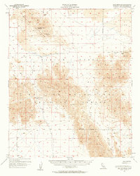
1955 Map of Lead Mountain
USGS Topo · Published 1961About this map
The Bullion Mountains dominate this mid-century survey of the California desert, capturing a landscape defined by volcanic geology and mining activity. Remnants of the region's extraction history are documented at the War Eagle Mine and Ametica Mine, alongside scattered prospects found in the northern heights near Lead Mountain. The topography is marked by extensive deposits of lava and the arid expanse of Bristol Lake to the northeast. Human presence is sparse, characterized primarily by isolated infrastructure like the Dry Well and an intricate network of jeep trails. Large portions of the terrain fall within the Naval Reservation Boundary, reflecting the area's mid-century role as a military testing ground. To the south, the Cleghorn Lakes and Cleghorn Pass provide key geographical landmarks amidst the high peaks of Bullion and Bullion East.
Find a feature on this map
18 named features on this map. Tap any name to fly to it.
Don’t see what you’re looking for? This feature index may not catch every label — zoom into the map to look around manually.
Map Details
Editions of this 1955 Lead Mountain Map
2 editions found

Other maps of this area

1942 · Amboy
USGS Topo · 1:250,000

1943 · Amboy
USGS Topo · 1:250,000

1953 · San Bernardino
USGS Topo · 1:250,000

1954 · Needles
USGS Topo · 1:250,000

1954 · Bristol Lake NW
USGS Topo · 1:24,000

1954 · Amboy Crater
USGS Topo · 1:24,000

1954 · Bagdad SW
USGS Topo · 1:24,000

1954 · Bristol Lake SW
USGS Topo · 1:24,000

1954 · Ludlow SE
USGS Topo · 1:24,000

1954 · Valley Mtn
USGS Topo · 1:24,000