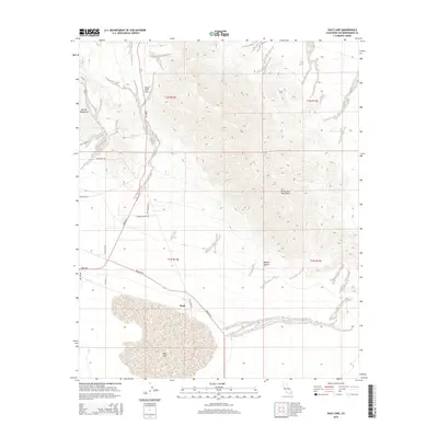
2015 Map of Dale Lake
USGS Topo · Published 2015About this map
Dale Lake dominates the southern basin of this arid landscape, its dry bed situated at the foot of the Sheep Hole Mountains and the Bullion Mountains. This area of the Mojave Desert is defined by rugged relief and the strategic transit routes that navigate it, most notably the winding path of Amboy Rd as it climbs through Sheep Hole Pass. The small settlement of Bush serves as a lone outpost along the desert floor, located near the intersection of several industrial and local tracks.
Find a feature on this map
21 named features on this map. Tap any name to fly to it.
Don’t see what you’re looking for? This feature index may not catch every label — zoom into the map to look around manually.
Map Details
Editions of this 2015 Dale Lake Map
This is the sole edition of this map. No revisions or reprints were ever made.
Other maps of this area

1942 · Amboy
USGS Topo · 1:250,000

1943 · Amboy
USGS Topo · 1:250,000

1954 · Needles
USGS Topo · 1:250,000

1954 · Bristol Lake SW
USGS Topo · 1:24,000
1955 · Cleghorn Lakes
USGS Topo · 1:24,000

1955 · Lead Mountain
USGS Topo · 1:62,500

1956 · Needles
USGS Topo · 1:250,000

1956 · Dale Lake
USGS Topo · 1:62,500

1956 · Bristol Lake
USGS Topo · 1:62,500
1956 · Valley Mountain
USGS Topo · 1:62,500