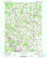
1946 Map of Dalton
USGS Topo · Published 1991About this map
The borough of Dalton and the surrounding townships of Lackawanna County are defined by a network of small farming communities and private lakes in this mid-century portrait. The landscape is dotted with family-named landmarks like Lee Hill and Bull Hill, alongside numerous local burial grounds such as Shoemaker Cem and Hickory Grove Cem. The presence of the Erie-Lackawanna railroad through Glenburn and La Plume Sta highlights the transportation corridor that sustained these rural boroughs. Educational and community anchors are visible at Kamp Kewanee and the Ackerly Fairgrounds, while the northern portion of the map shows the transition into Wyoming County. The drainage patterns of South Branch Tunkhannock Creek and Kennedy Creek connect a series of glacial ponds, including Lake Kewanee and Lilly Lake, which served as local centers of recreation and water supply during this period of settlement.
Find a feature on this map
73 named features on this map. Tap any name to fly to it.
Don’t see what you’re looking for? This feature index may not catch every label — zoom into the map to look around manually.
Map Details
Editions of this 1946 Dalton Map
5 editions found
Other maps of this area

1889 · Scranton
USGS Topo · 1:62,500

1891 · Scranton
USGS Topo · 1:62,500

1892 · Dundaff
USGS Topo · 1:62,500

1893 · Pittston
USGS Topo · 1:62,500

1893 · Scranton
USGS Topo · 1:62,500

1943 · Scranton
USGS Topo · 1:125,000

1946 · Tunkhannock
USGS Topo · 1:62,500

1946 · Dalton
USGS Topo · 1:24,000

1946 · Olyphant
USGS Topo · 1:24,000

1946 · Ransom
USGS Topo · 1:24,000
Featured Places
- Scott Township, PA
- Glenburn Township, PA
- Dalton, PA
- La Plume Township, PA
- Carpenter Town, Benton Township