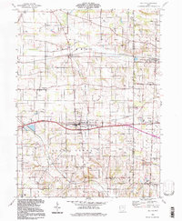
1994 Map of Dalton
USGS Topo · Published 1998About this map
Dalton serves as the central hub of this agricultural and industrial landscape in the mid-1990s, positioned along a major transit corridor near the border of Wayne and Stark Counties. The terrain is defined by the winding paths of Sugar Creek and Newman Creek, which intersect a rural grid of roads like Alabama Avenue and Wooster Street. Historical infrastructure remains visible through the Old Newman Railroad Grade and sections of Old Grade, marking the evolution of local transport. Genealogy and local history researchers will find a wealth of specific landmarks, including Old Presbyterian Cem, Van Kirk Cem, and several country churches like Martins Ch and Pleasant View Ch. The southern reaches are anchored by the Sonnenberg Sch and the community of Kidron Station, while the landscape is dotted with numerous Gas Wells and Mine Dumps, reflecting a long history of resource extraction alongside the region's farming roots.
Find a feature on this map
42 named features on this map. Tap any name to fly to it.
Don’t see what you’re looking for? This feature index may not catch every label — zoom into the map to look around manually.
Map Details
Editions of this 1994 Dalton Map
This is the sole edition of this map. No revisions or reprints were ever made.
Other maps of this area

1901 · Massillon
USGS Topo · 1:62,500

1901 · Wooster
USGS Topo · 1:62,500

1903 · Massillon
USGS Topo · 1:62,500

1903 · Wooster
USGS Topo · 1:62,500

1914 · Navarre
USGS Topo · 1:62,500

1915 · Millersburg
USGS Topo · 1:62,500

1943 · Millersburg
USGS Topo · 1:62,500

1944 · Navarre
USGS Topo · 1:62,500

1951 · Canton
USGS Topo · 1:250,000

1953 · Canton
USGS Topo · 1:250,000