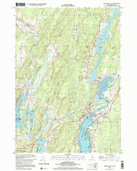
2000 Map of Damariscotta
USGS Topo · Published 2001About this map
The coastal and riverine landscape of Lincoln County is defined by the branching estuaries of the Sheepscot River and Damariscotta River. At the turn of the millennium, this area remains a network of historic villages and tidal flats. Newcastle and Damariscotta serve as the primary hubs, linked by bridges near Jacks Pt and Lewis Pt. Further inland, the map captures the quiet character of Alna, Head Tide, and North Newcastle, where small family cemeteries like Alna Cem and old country churches including St Patricks Ch dot the wooded hills. The geography is notably shaped by water, from the narrow Dyer River valley to the broad expanse of Salt Bay and the islands of Damariscotta Lake, such as Spectacle Island. This survey documents a traditional Maine settlement pattern where community life follows the ridges and shorelines of the Marsh River and Deer Meadow Brook.
Find a feature on this map
53 named features on this map. Tap any name to fly to it.
Don’t see what you’re looking for? This feature index may not catch every label — zoom into the map to look around manually.
Map Details
Editions of this 2000 Damariscotta Map
This is the sole edition of this map. No revisions or reprints were ever made.
Other maps of this area

1893 · Wiscasset
USGS Topo · 1:62,500

1893 · Boothbay
USGS Topo · 1:62,500

1904 · Monhegan
USGS Topo · 1:62,500

1906 · Monhegan
USGS Topo · 1:62,500

1913 · Waldoboro
USGS Topo · 1:48,000

1915 · Waldoboro
USGS Topo · 1:62,500

1941 · Waldoboro
USGS Topo · 1:62,500

1941 · Boothbay
USGS Topo · 1:62,500

1943 · Boothbay
USGS Topo · 1:62,500

1944 · Wiscasset
USGS Topo · 1:62,500