
1920 Map of Damascus
USGS Topo · Published 1956About this map
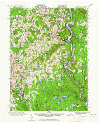
The Delaware River serves as the central artery of this 1920 survey, marking the jagged boundary between Pennsylvania and New York. The landscape is defined by a dense network of early 20th-century rural infrastructure, including an Oil Pumping Station near Cochecton and the Erie Railroad tracing the eastern riverbank. The river valley is punctuated by small hamlets like Milanville and Narrowsburg, while the surrounding uplands of Damascus and Oregon townships are dotted with family-named schools such as Kester School and Burcher School. This era shows a high density of local educational and religious centers, such as St Josephs Church, indicating a peak of settled rural life before the mid-century shift toward larger consolidated townships. Many water bodies, including Beach Lake and Welcome Lake, reflect the region's developing character as a recreational and residential destination.
Find a feature on this map
111 named features on this map. Tap any name to fly to it.
Don’t see what you’re looking for? This feature index may not catch every label — zoom into the map to look around manually.
Map Details
Editions of this 1920 Damascus Map
2 editions found
Other maps of this area

1892 · Honesdale
USGS Topo · 1:62,500

1913 · Milford
USGS Topo · 1:62,500

1915 · Milford
USGS Topo · 1:62,500

1920 · Long Eddy
USGS Topo · 1:62,500

1921 · Long Eddy
USGS Topo · 1:48,000

1921 · Livingston Manor
USGS Topo · 1:62,500

1922 · White Lake
USGS Topo · 1:62,500

1923 · Damascus
USGS Topo · 1:62,500

1923 · Long Eddy
USGS Topo · 1:62,500

1923 · Livingston Manor
USGS Topo · 1:62,500