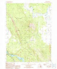
1990 Map of Dana
USGS Topo · Published 1990About this map
Dana sits at the northern edge of this high-country landscape, where the waters of Bear Creek and Thousand Springs begin their descent toward the Fall River. The topography is dominated by the volcanic rise of Soldier Mountain and Fort Mountain, surrounded by the extensive timberlands of the Shasta National Forest. This 1990 provisional survey records a rural transition, from the small crossroads at Horns Four Corners to the developed recreational areas near Lake Britton. Significant water management features, such as Coyote Flat Reservoir and Warner Grade Reservoir, illustrate the hydrological engineering required to support the region's drainage into the Pit River. For the hiker or researcher, the route of the Pacific Crest National Scenic Trail is clearly delineated as it winds through the southern ridges near Arknight Flat.
Find a feature on this map
27 named features on this map. Tap any name to fly to it.
Don’t see what you’re looking for? This feature index may not catch every label — zoom into the map to look around manually.
Map Details
Editions of this 1990 Dana Map
This is the sole edition of this map. No revisions or reprints were ever made.
Other maps of this area

1886 · Lassen Peak
USGS Topo · 1:250,000

1886 · Modoc Lava Bed
USGS Topo · 1:250,000

1892 · Modoc Lava-Bed
USGS Topo · 1:250,000

1892 · Lassen Peak
USGS Topo · 1:250,000

1894 · Lassen Peak
USGS Topo · 1:250,000

1932 · Bartle
USGS Topo · 1:96,000

1935 · Burney
USGS Topo · 1:96,000

1939 · Burney
USGS Topo · 1:125,000

1939 · Halls Flat
USGS Topo · 1:125,000

1939 · Bartle
USGS Topo · 1:125,000