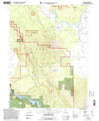
1995 Map of Dana
USGS Topo · Published 1998About this map
The northern reaches of the Fall River Valley converge with the steep timberlands of the Shasta National Forest on this mid-1990s survey. The small settlement of Dana sits near the headwaters of the Fall River, while the Dana Cem remains as a focal point for genealogical research in this rural pocket of Shasta County. The landscape is defined by its water management, featuring several high-elevation impoundments such as Coyote Flat Reservoir, Soldier Mountain Reservoir, and Warner Grade Reservoir.
Find a feature on this map
36 named features on this map. Tap any name to fly to it.
Don’t see what you’re looking for? This feature index may not catch every label — zoom into the map to look around manually.
Map Details
Editions of this 1995 Dana Map
2 editions found
Other maps of this area

1886 · Lassen Peak
USGS Topo · 1:250,000

1886 · Modoc Lava Bed
USGS Topo · 1:250,000

1892 · Modoc Lava-Bed
USGS Topo · 1:250,000

1892 · Lassen Peak
USGS Topo · 1:250,000

1894 · Lassen Peak
USGS Topo · 1:250,000

1932 · Bartle
USGS Topo · 1:96,000

1935 · Burney
USGS Topo · 1:96,000

1939 · Burney
USGS Topo · 1:125,000

1939 · Halls Flat
USGS Topo · 1:125,000

1939 · Bartle
USGS Topo · 1:125,000