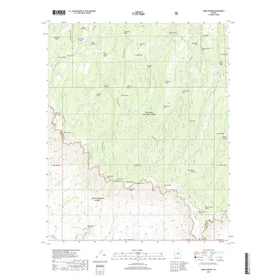
2018 Map of Dane Canyon
USGS Topo · Published 2018About this map
The Mogollon Rim forms a massive geological divide across this portion of central Arizona, separating the Coconino National Forest on the high Mogollon Plateau from the Tonto National Forest below the escarpment. This high-country landscape is defined by its water sources and historical transit routes, including the General Crook Trail which follows the rim edge and the Arizona National Scenic Trail cutting through the western section. Dozens of named springs and tanks, such as Pinchot Spring and Backhoe Tank Number Six, indicate the critical nature of water management in this arid timberland. The map provides a detailed view of the complex drainage systems, where deep cuts like Houston Draw and Maverick Canyon drop away from ridges like Turkey Pen Ridge, illustrating the challenging terrain that early foresters and ranchers navigated.
Find a feature on this map
87 named features on this map. Tap any name to fly to it.
Don’t see what you’re looking for? This feature index may not catch every label — zoom into the map to look around manually.
Map Details
Editions of this 2018 Dane Canyon Map
This is the sole edition of this map. No revisions or reprints were ever made.
Other maps of this area

1887 · Verde
USGS Topo · 1:250,000

1892 · Verde
USGS Topo · 1:250,000

1934 · Pine
USGS Topo · 1:62,500

1934 · Promontory Butte
USGS Topo · 1:62,500

1939 · Promontory Butte
USGS Topo · 1:62,500

1940 · Pine
USGS Topo · 1:62,500

1952 · Pine
USGS Topo · 1:62,500

1952 · Promontory Butte
USGS Topo · 1:62,500

1954 · Holbrook
USGS Topo · 1:250,000

1957 · Holbrook
USGS Topo · 1:250,000