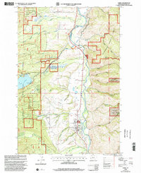
1998 Map of Darby
USGS Topo · Published 2002About this map
Darby serves as a central hub along the Bitterroot River in this late-twentieth-century study of Ravalli County. The town is marked by its community landmarks including the Darby Ranger Station, an Athletic Field, and the Lone Pine Cem situated just to the north. The landscape is defined by the valley's complex water management systems, notably the Irrigation Siphon, Irrigation Supply Canal, and the Hedge Ditch, which redirect water from the mountains to support the valley floor.
Find a feature on this map
50 named features on this map. Tap any name to fly to it.
Don’t see what you’re looking for? This feature index may not catch every label — zoom into the map to look around manually.
Map Details
Editions of this 1998 Darby Map
This is the sole edition of this map. No revisions or reprints were ever made.
Other maps of this area

1901 · Hamilton
USGS Topo · 1:125,000

1956 · Elk City
USGS Topo · 1:250,000

1956 · Hamilton
USGS Topo · 1:250,000

1959 · Hamilton
USGS Topo · 1:250,000

1960 · Elk City
USGS Topo · 1:250,000

1960 · Hamilton
USGS Topo · 1:250,000

1964 · Hamilton
USGS Topo · 1:250,000

1964 · Hamilton South
USGS Topo · 1:24,000

1964 · Burnt Ridge
USGS Topo · 1:24,000

1964 · Darby
USGS Topo · 1:24,000