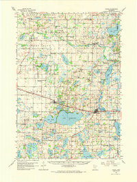
1958 Map of Dassel
USGS Topo · Published 1974About this map
Lake Washington and the Crow River dominate this central Minnesota landscape, where a dense network of glacial lakes defines the local geography. The settlements of Dassel and Darwin serve as primary hubs along the Burlington Northern railroad, a corridor that also passes by smaller water bodies like Sellards Lake and Lake Darwin. To the north, the village of Forest City sits near the riverbanks, while Kingston anchors the northeastern portion of the quadrangle.
Find a feature on this map
83 named features on this map. Tap any name to fly to it.
Don’t see what you’re looking for? This feature index may not catch every label — zoom into the map to look around manually.
Map Details
Editions of this 1958 Dassel Map
2 editions found
Other maps of this area

1951 · Annandale
USGS Topo · 1:62,500

1953 · New Ulm
USGS Topo · 1:250,000

1953 · Saint Cloud
USGS Topo · 1:250,000

1957 · Saint Cloud
USGS Topo · 1:250,000

1957 · New Ulm
USGS Topo · 1:250,000

1958 · New Ulm
USGS Topo · 1:250,000

1958 · Saint Cloud
USGS Topo · 1:250,000

1958 · Glencoe
USGS Topo · 1:62,500

1958 · Dassel
USGS Topo · 1:62,500

1958 · Cokato
USGS Topo · 1:62,500