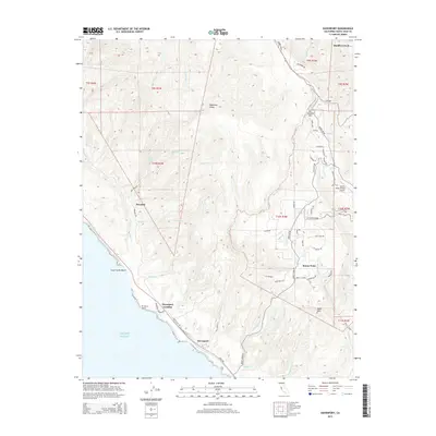
2015 Map of Davenport
USGS Topo · Published 2015About this map
Davenport and the surrounding coastline of Santa Cruz County are defined by the steep elevation change from the Pacific Ocean to the summits of the Santa Cruz Mountains. This landscape transition is most evident at Ben Lomond Mtn and Bald Mtn, where numerous drainages like Scott Cr and San Vicente Cr have carved deep canyons toward the shore. The coastal economy and infrastructure are highlighted by Cement Plant Rd and the maritime access point at Davenport Landing. Further inland, the map captures a network of specialized local routes, including the curiously named Ice Cream Grade and Smith Grade, which connect the upland community of Bonny Doon and the Bonny Doon Village Airport to the agricultural and residential pockets at Swanton. This survey documents the intersection of rugged topography and established coastal settlements in the early twenty-first century.
Find a feature on this map
68 named features on this map. Tap any name to fly to it.
Don’t see what you’re looking for? This feature index may not catch every label — zoom into the map to look around manually.
Map Details
Editions of this 2015 Davenport Map
This is the sole edition of this map. No revisions or reprints were ever made.
Other maps of this area

1902 · Santa Cruz
USGS Topo · 1:125,000

1940 · Ano Nuevo
USGS Topo · 1:62,500

1941 · Ano Nuevo Pt.
USGS Topo · 1:62,500

1942 · Ano Nuevo
USGS Topo · 1:62,500

1947 · San Francisco
USGS Topo · 1:250,000

1948 · Santa Cruz
USGS Topo · 1:250,000

1948 · San Francisco
USGS Topo · 1:250,000

1948 · Ano Nuevo
USGS Topo · 1:62,500
1954 · Santa Cruz
USGS Topo · 1:24,000

1955 · San Francisco
USGS Topo · 1:250,000