
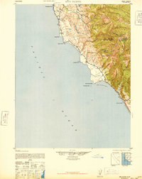
1942 Map of Ano Nuevo
USGS Topo · Published 1942About this map
The California coast between San Mateo and Santa Cruz counties appears here as a landscape of coastal agriculture and rugged oceanfront during the early 1940s. Landmark points such as Pigeon Point and Franklin Point define the jagged shoreline, while Año Nuevo Island sits just offshore from the Año Nuevo Point headland. Inland, the topography transitions quickly from the sea into the complex drainage systems of the Santa Cruz Mountains. Coastal life is evidenced by the presence of Coastways Ranch and Whitehouse Camp, alongside natural features like Lake Lucerne. Deep in the canyons, the map records Notley Junction and Rancho Del Oso, connected by winding routes like Basin Road. This 1942 edition reflects a period of military concern, with topographic details compiled from aerial photography by the 91st Observation Squadron of the Army Air Corps.
Find a feature on this map
36 named features on this map. Tap any name to fly to it.
Don’t see what you’re looking for? This feature index may not catch every label — zoom into the map to look around manually.
Map Details
Editions of this 1942 Ano Nuevo Map
2 editions found
Other maps of this area

1897 · Palo Alto
USGS Topo · 1:62,500

1899 · Palo Alto
USGS Topo · 1:62,500

1902 · Santa Cruz
USGS Topo · 1:125,000

1940 · Halfmoon Bay
USGS Topo · 1:62,500

1940 · Ano Nuevo
USGS Topo · 1:62,500

1941 · Ano Nuevo Pt.
USGS Topo · 1:62,500

1941 · Palo Alto
USGS Topo · 1:62,500

1943 · Palo Alto
USGS Topo · 1:62,500

1943 · Halfmoon Bay
USGS Topo · 1:62,500

1947 · San Francisco
USGS Topo · 1:250,000