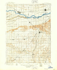
1899 Map of David City
USGS Topo · Published 1949About this map
David City serves as the focal point of this late 19th-century landscape, positioned south of the Platte River where the high plains begin to break into the drainage of the Big Blue River. The region is defined by a dense network of competing rail lines that fueled the growth of settlements like Schuyler and Columbus. The Union Pacific R. R. and several branches of the Burlington and Missouri River R. R. connect a grid of farming townships, each anchoring local life at junctions like Garrison and Surprise. Significant topographic detail reveals the transition from the flat river valley into the broken terrain of Summit and Reading townships. Beyond the major hubs, smaller stops such as Mahlon and Wayland reflect the early settlement patterns of Butler and Polk counties before the consolidation of rural communities.
Find a feature on this map
71 named features on this map. Tap any name to fly to it.
Don’t see what you’re looking for? This feature index may not catch every label — zoom into the map to look around manually.
Map Details
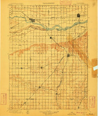
Editions of this 1899 David City Map
3 editions found
Other maps of this area

1896 · Stromsburg
USGS Topo · 1:125,000

1897 · Lincoln
USGS Topo · 1:125,000

1898 · York
USGS Topo · 1:125,000

1899 · Wahoo
USGS Topo · 1:125,000

1899 · David City
USGS Topo · 1:125,000

1899 · York
USGS Topo · 1:125,000

1934 · Seward
USGS Topo · 1:48,000

1934 · Utica
USGS Topo · 1:62,500

1937 · Utica
USGS Topo · 1:62,500

1939 · Seward
USGS Topo · 1:62,500