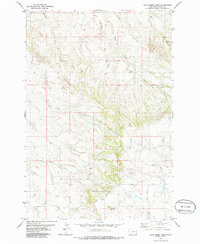
1979 Map of Davis Creek East
USGS Topo · Published 1986About this map
Chalk Buttes dominates the southeastern horizon of this Carter County landscape, where the high ridges give way to a complex network of intermittent drainages. Mapped during the 1970s, the terrain is defined by the carved paths of Davis Creek and Whitetail Creek, along with several seasonal flows such as South Spring Creek and Dry Creek. The area is largely characterized by open rangeland and intricate topography, with landmark elevations like Saddle Butte providing clear points of orientation for those tracking historical land use. Scattered evidence of water management and local infrastructure, including several locations marked simply as Well, indicates the necessity of reliable water sources for the cattle ranching operations that have long anchored this part of Montana. Fine red dashed lines throughout the map provide a unique record of selected fence lines, tracing the boundaries of private holdings and public lands during this era.
Find a feature on this map
12 named features on this map. Tap any name to fly to it.
Don’t see what you’re looking for? This feature index may not catch every label — zoom into the map to look around manually.
Map Details
Editions of this 1979 Davis Creek East Map
This is the sole edition of this map. No revisions or reprints were ever made.
Other maps of this area

1954 · Ekalaka
USGS Topo · 1:250,000

1956 · Ekalaka
USGS Topo · 1:250,000

1958 · Ekalaka
USGS Topo · 1:250,000

1965 · Ekalaka
USGS Topo · 1:250,000

1979 · W L Butte
USGS Topo · 1:24,000

1979 · Dutchman Creek
USGS Topo · 1:24,000

1979 · Blacktail Creek SE
USGS Topo · 1:24,000

1979 · Blacktail Creek SW
USGS Topo · 1:24,000

1979 · Beaver Flats South
USGS Topo · 1:24,000

1979 · Chalk Buttes
USGS Topo · 1:24,000