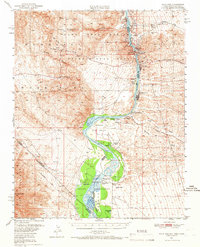
1950 Map of Davis Dam
USGS Topo · Published 1966About this map
Davis Dam serves as the focal point of this mid-century survey, capturing the Colorado River at a critical moment of engineering transformation. The map shows the blue hatching of the Lake Mohave reservoir, indicating the area destined for submergence as waters rose behind the new dam. This hydraulic change is contrasted by the preservation of older historical layers along the riverbanks, including the Fort Mohave (Ruins) and the Mohave City (Site) within the Fort Mohave Indian Reservation.
Find a feature on this map
52 named features on this map. Tap any name to fly to it.
Don’t see what you’re looking for? This feature index may not catch every label — zoom into the map to look around manually.
Map Details
Editions of this 1950 Davis Dam Map
2 editions found
Other maps of this area

1886 · Camp Mohave
USGS Topo · 1:250,000

1892 · Camp Mohave
USGS Topo · 1:250,000

1903 · Needles
USGS Topo · 1:125,000

1904 · Needles Special
USGS Topo · 1:125,000

1926 · Mohave City
USGS Topo · 1:96,000

1942 · Camp Mohave
USGS Topo · 1:250,000

1943 · Bannock
USGS Topo · 1:62,500

1947 · Kingman
USGS Topo · 1:250,000

1948 · Kingman
USGS Topo · 1:250,000

1950 · Davis Dam
USGS Topo · 1:62,500