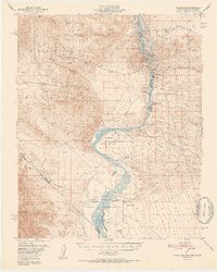
1952 Map of Davis Dam
USGS Topo · Published 1952About this map
Davis Dam stands as the central engineering feat along the Colorado River in this early 1950s study of the tristate border region. The landscape is a study in transition, documenting the early development of Bullhead City and Katherine alongside remnants of an earlier frontier era. The river corridor preserves significant historical sites, including the Mohave City (Site) and the Fort Mohave (Ruins) within the Fort Mohave Indian Reservation. The presence of the Katherine Mine (Inactive) and numerous Clay Borrow Pits indicates the region's industrial and extractive activities during the mid-century. Several family-named properties like Hardyville Ranch and LeClair Ranch are scattered along the riverbanks, marking the local ranching footprint before more intensive desert development took hold. The map also delineates the northern reaches of the Lake Mead National Recreation Area, where the river winds through Pyramid Canyon and past distinctive landmarks like Bulls Head Rock.
Find a feature on this map
42 named features on this map. Tap any name to fly to it.
Don’t see what you’re looking for? This feature index may not catch every label — zoom into the map to look around manually.
Map Details
Editions of this 1952 Davis Dam Map
2 editions found

Other maps of this area

1886 · Camp Mohave
USGS Topo · 1:250,000

1892 · Camp Mohave
USGS Topo · 1:250,000

1903 · Needles
USGS Topo · 1:125,000

1904 · Needles Special
USGS Topo · 1:125,000

1926 · Mohave City
USGS Topo · 1:96,000

1942 · Camp Mohave
USGS Topo · 1:250,000

1943 · Bannock
USGS Topo · 1:62,500

1947 · Kingman
USGS Topo · 1:250,000

1948 · Kingman
USGS Topo · 1:250,000

1950 · Davis Dam
USGS Topo · 1:62,500