
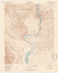
1952 Map of Davis Dam
USGS Topo · Published 1952About this map
Davis Dam anchors this mid-century landscape along the Colorado River, illustrating the river's transformation within the Lake Mead National Recreational Area. The map reveals a layering of history where burgeoning settlements like Bullhead City and infrastructure such as the Air Strip and Tristate area sit adjacent to significant archaeological and historical sites. Notable among these are the Fort Mohave (Ruins), the Mohave City (Site), and the Hardyville (Site), marking the early river ports and military outposts that predated the twentieth-century hydroelectric projects.
Find a feature on this map
49 named features on this map. Tap any name to fly to it.
Don’t see what you’re looking for? This feature index may not catch every label — zoom into the map to look around manually.
Map Details
Editions of this 1952 Davis Dam Map
2 editions found
Other maps of this area

1886 · Camp Mohave
USGS Topo · 1:250,000

1892 · Camp Mohave
USGS Topo · 1:250,000

1903 · Needles
USGS Topo · 1:125,000

1904 · Needles Special
USGS Topo · 1:125,000

1926 · Mohave City
USGS Topo · 1:96,000

1942 · Camp Mohave
USGS Topo · 1:250,000

1943 · Bannock
USGS Topo · 1:62,500

1947 · Kingman
USGS Topo · 1:250,000

1948 · Kingman
USGS Topo · 1:250,000

1950 · Davis Dam
USGS Topo · 1:62,500