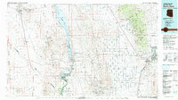
1982 Map of Davis Dam
USGS Topo · Published 1983About this map
The Colorado River serves as the central artery for this tri-state corridor, where the Davis Dam regulates the waters downstream of Lake Mead National Recreation Area. By the early 1980s, the riverside communities of Laughlin and Bullhead City were expanding rapidly, even as the surrounding terrain remained defined by its long-standing mining heritage. The landscape is a study in industrial persistence, from the clustered claims around Searchlight in the west to the dense concentration of shafts like the Mineral Park Mine and New Era Mines in the Cerbat Mountains.
Find a feature on this map
72 named features on this map. Tap any name to fly to it.
Don’t see what you’re looking for? This feature index may not catch every label — zoom into the map to look around manually.
Map Details
Editions of this 1982 Davis Dam Map
2 editions found
Other maps of this area

1886 · Diamond Creek
USGS Topo · 1:250,000

1886 · Camp Mohave
USGS Topo · 1:250,000

1892 · Diamond Creek
USGS Topo · 1:250,000

1892 · Camp Mohave
USGS Topo · 1:250,000

1903 · Needles
USGS Topo · 1:125,000

1904 · Needles Special
USGS Topo · 1:125,000

1910 · Ivanpah
USGS Topo · 1:250,000

1912 · Ivanpah
USGS Topo · 1:250,000

1923 · Signal
USGS Topo · 1:250,000

1926 · Nelson
USGS Topo · 1:96,000