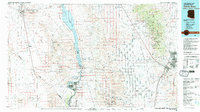
1982 Map of Davis Dam
USGS Topo · Published 1983About this map
Laughlin and Bullhead City anchor this desert landscape along the Colorado River, where the Davis Dam regulates the water flow just south of the Lake Mead National Recreation Area. The map reveals an intricate network of desert washes like Detrital Wash and Sacramento Wash that carve through the vast basins between the Black Mountains and the Cerbat Mountains. To the east, Kingman serves as a major transportation hub where the Atchison Topeka and Santa Fe railroad meets significant routes through the Sacramento Valley.
Find a feature on this map
59 named features on this map. Tap any name to fly to it.
Don’t see what you’re looking for? This feature index may not catch every label — zoom into the map to look around manually.
Map Details
Editions of this 1982 Davis Dam Map
2 editions found
Other maps of this area

1886 · Diamond Creek
USGS Topo · 1:250,000

1886 · Camp Mohave
USGS Topo · 1:250,000

1892 · Diamond Creek
USGS Topo · 1:250,000

1892 · Camp Mohave
USGS Topo · 1:250,000

1903 · Needles
USGS Topo · 1:125,000

1904 · Needles Special
USGS Topo · 1:125,000

1910 · Ivanpah
USGS Topo · 1:250,000

1912 · Ivanpah
USGS Topo · 1:250,000

1923 · Signal
USGS Topo · 1:250,000

1926 · Nelson
USGS Topo · 1:96,000