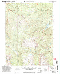
2000 Map of Davis Peak
USGS Topo · Published 2004About this map
Davis Peak towers over the high-country landscape of the Park Range, marking a significant point within the Mount Zirkel Wilderness at the start of the 21st century. This map traces the jagged path of the Continental Divide as it separates the Jackson and Routt county line. The terrain is defined by a network of drainage systems including Damfino Creek and the Encampment River, which flow through high-altitude basins like Buffalo Park and Dinner Park.
Find a feature on this map
30 named features on this map. Tap any name to fly to it.
Don’t see what you’re looking for? This feature index may not catch every label — zoom into the map to look around manually.
Map Details
Editions of this 2000 Davis Peak Map
This is the sole edition of this map. No revisions or reprints were ever made.
Other maps of this area

1911 · Hahns Peak
USGS Topo · 1:125,000

1913 · Hahns Peak
USGS Topo · 1:125,000

1939 · Saratoga
USGS Topo · 1:125,000

1954 · Rawlins
USGS Topo · 1:250,000

1954 · Craig
USGS Topo · 1:250,000

1955 · Davis Peak
USGS Topo · 1:24,000

1955 · Mount Zirkel
USGS Topo · 1:24,000

1955 · Pearl
USGS Topo · 1:24,000
1956 · Boettcher Lake
USGS Topo · 1:24,000

1956 · Pearl
USGS Topo · 1:62,500