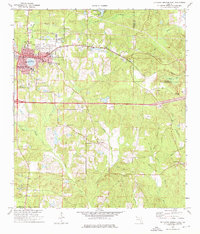
1973 Map of De Funiak Springs East
USGS Topo · Published 1976About this map
De Funiak Springs serves as the focal point of this 1970s Walton County study, its circular street grid radiating from the perfectly round Lake De Funiak. The Louisville and Nashville railroad corridor defines the east-west axis of the landscape, connecting the town with smaller outposts like Koerber and Argyle. Further south, the map documents the rural community of Eucheeanna, a site of significant local history as a former county seat before the rail-driven growth of the late 19th century shifted development northward.
Find a feature on this map
48 named features on this map. Tap any name to fly to it.
Don’t see what you’re looking for? This feature index may not catch every label — zoom into the map to look around manually.
Map Details
Editions of this 1973 De Funiak Springs East Map
2 editions found

Other maps of this area

1935 · De Funiak Springs
USGS Topo · 1:48,000

1938 · De Funiak Springs
USGS Topo · 1:62,500

1948 · Ponce De Leon
USGS Topo · 1:24,000

1949 · Glendale
USGS Topo · 1:62,500

1949 · Redbay
USGS Topo · 1:24,000
1950 · Prosperity
USGS Topo · 1:24,000

1950 · Ponce De Leon
USGS Topo · 1:24,000

1950 · Redbay
USGS Topo · 1:24,000
1951 · Glendale
USGS Topo · 1:62,500

1954 · Tallahassee
USGS Topo · 1:250,000