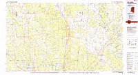
1984 Map of De Kalb
USGS Topo · Published 1984About this map
De Kalb and the surrounding borderlands of Kemper County are defined by a complex network of river systems and state-managed lands during the early 1980s. The landscape transitions from the higher ground of Gholson Mountain down to the extensive wetlands of the Okatibbee State Wildlife Area and Okatibbee Lake. This era shows a region balanced between the traditional timber and agricultural economies of settlements like Shuqualak and Scooba, and the strategic military presence at the Naval Auxiliary Air Station near Meridian Naval Air Station. Significant cultural boundaries are evident with the Choctaw Indian Reservation and the historical grounds of Nana Waiya State Park in the northwest. The drainage patterns of the Sucarnoochee River and Chickasawhay River illustrate the natural topography that shaped early trade routes and rail corridors, including the Illinois Central Gulf and Southern lines.
Find a feature on this map
78 named features on this map. Tap any name to fly to it.
Don’t see what you’re looking for? This feature index may not catch every label — zoom into the map to look around manually.
Map Details
Editions of this 1984 De Kalb Map
2 editions found
Other maps of this area

1921 · Meridian
USGS Topo · 1:48,000

1923 · Meridian
USGS Topo · 1:62,500

1927 · Eutaw
USGS Topo · 1:48,000

1929 · Epes
USGS Topo · 1:48,000

1931 · Eutaw
USGS Topo · 1:62,500

1932 · Epes
USGS Topo · 1:62,500

1947 · Forkland
USGS Topo · 1:24,000

1948 · Mc Dowell
USGS Topo · 1:24,000

1949 · Mc Dowell
USGS Topo · 1:24,000

1949 · Forkland
USGS Topo · 1:24,000