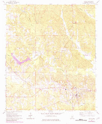
1963 Map of De Kalb
USGS Topo · Published 1982About this map
De Kalb serves as the focal point of this Kemper County landscape, where the town’s residential streets and public utility structures, such as a Water Tank and Substation, indicate a established local hub. The surrounding terrain is defined by a dense network of waterways, including Sucarnoochee Creek and Running Tiger Creek, which drain the varied topography. A significant historical marker is the Old Railroad Grade running through the southeastern section, tracing a former transport corridor that once moved timber or agricultural goods through the region.
Find a feature on this map
27 named features on this map. Tap any name to fly to it.
Don’t see what you’re looking for? This feature index may not catch every label — zoom into the map to look around manually.
Map Details
Editions of this 1963 De Kalb Map
3 editions found
Other maps of this area

1953 · Meridian
USGS Topo · 1:250,000

1957 · Meridian
USGS Topo · 1:250,000

1962 · Lynville
USGS Topo · 1:24,000

1962 · Lauderdale NW
USGS Topo · 1:24,000

1962 · Preston
USGS Topo · 1:24,000

1962 · Oak Grove
USGS Topo · 1:24,000

1962 · Moscow
USGS Topo · 1:24,000

1962 · Shuqualak
USGS Topo · 1:24,000

1963 · De Kalb
USGS Topo · 1:24,000

1963 · Townsend
USGS Topo · 1:24,000