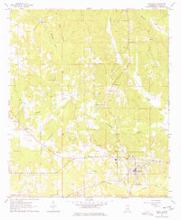
1963 Map of De Kalb
USGS Topo · Published 1978About this map
De Kalb serves as the focal point of this 1963 survey, situated where the high ground meets the headwaters of the Sucarnoochee Creek. The town's layout is clearly defined, showing the distribution of buildings around its central core near a prominent Water Tank and Substation. The surrounding Kemper County landscape is a network of small watercourses and family-named landmarks that hint at a deep-rooted rural community. To the southeast, an Old Railroad Grade marks a former transportation corridor through the bottomlands of Hull Branch and Snoody Creek.
Find a feature on this map
23 named features on this map. Tap any name to fly to it.
Don’t see what you’re looking for? This feature index may not catch every label — zoom into the map to look around manually.
Map Details
Editions of this 1963 De Kalb Map
3 editions found
Other maps of this area

1953 · Meridian
USGS Topo · 1:250,000

1957 · Meridian
USGS Topo · 1:250,000

1962 · Lynville
USGS Topo · 1:24,000

1962 · Lauderdale NW
USGS Topo · 1:24,000

1962 · Preston
USGS Topo · 1:24,000

1962 · Oak Grove
USGS Topo · 1:24,000

1962 · Moscow
USGS Topo · 1:24,000

1962 · Shuqualak
USGS Topo · 1:24,000

1963 · De Kalb
USGS Topo · 1:24,000

1963 · Townsend
USGS Topo · 1:24,000