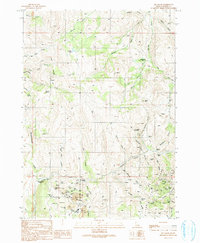
1990 Map of De Lamar
USGS Topo · Published 1991About this map
The silver-rich terrain of De Lamar Mountain and Florida Mountain dominates this late-twentieth-century study of the Owyhee mining district. This landscape is a dense network of industrial history, where complex tunnel systems and pits like the Golden Cycle Mine, Black Jack Mine, and Glen Silver Pit No 1 reveal the scale of local extraction. The settlement pattern shows the evolution of the region, anchored by the town of De Lamar and the historic locations of Democrat, Dewey, and Wagontown. Drainage systems such as Jordan Creek and Succor Creek cut through the high-elevation peaks, providing the water essential for processing ores. A labyrinth of four-wheel-drive roads connects dozens of prospects and adits, including the Chatauqua Mine and Banner Mine, illustrating the persistent search for mineral wealth across these slopes.
Find a feature on this map
82 named features on this map. Tap any name to fly to it.
Don’t see what you’re looking for? This feature index may not catch every label — zoom into the map to look around manually.
Map Details
Editions of this 1990 De Lamar Map
This is the sole edition of this map. No revisions or reprints were ever made.
Other maps of this area

1892 · Silver City
USGS Topo · 1:125,000

1894 · Silver City
USGS Topo · 1:125,000

1898 · Silver City
USGS Topo · 1:125,000

1955 · Jordan Valley
USGS Topo · 1:250,000

1955 · Boise
USGS Topo · 1:250,000

1957 · Jordan Valley
USGS Topo · 1:250,000

1958 · Boise
USGS Topo · 1:250,000

1958 · Jordan Valley
USGS Topo · 1:250,000

1962 · Boise
USGS Topo · 1:250,000

1965 · Triangle
USGS Topo · 1:62,500