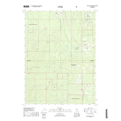
2018 Map of Dead Horse Summit
USGS Topo · Published 2018About this map
The high timberlands and volcanic terrain of Northern California define this landscape along the border of Siskiyou and Shasta counties. Centered on the Shasta National Forest, the map tracks the passage of the Pacific Crest National Scenic Trail as it winds through complex topography near Mushroom Rock and Bartle Gap. The upper reaches of the McCloud River cut through the northern sections, while smaller water bodies like Horse Lake and Curtis Lake dot the forested slopes.
Find a feature on this map
34 named features on this map. Tap any name to fly to it.
Don’t see what you’re looking for? This feature index may not catch every label — zoom into the map to look around manually.
Map Details
Editions of this 2018 Dead Horse Summit Map
This is the sole edition of this map. No revisions or reprints were ever made.
Other maps of this area

1886 · Modoc Lava Bed
USGS Topo · 1:250,000

1892 · Modoc Lava-Bed
USGS Topo · 1:250,000

1932 · Bartle
USGS Topo · 1:96,000

1939 · Bartle
USGS Topo · 1:125,000

1954 · Alturas
USGS Topo · 1:250,000

1958 · Alturas
USGS Topo · 1:250,000

1961 · Hambone
USGS Topo · 1:62,500

1961 · Pondosa
USGS Topo · 1:62,500
1961 · Big Bend
USGS Topo · 1:62,500

1961 · Bartle
USGS Topo · 1:62,500