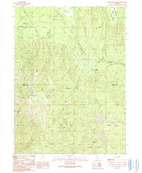
1990 Map of Dead Horse Summit
USGS Topo · Published 1990About this map
Shasta National Forest dominates this landscape along the border of Siskiyou and Shasta counties, where the high terrain forms a critical watershed for the McCloud River and Kosk Creek. The map documents a complex network of resource management and recreation, highlighted by the path of the Pacific Crest National Scenic Trail as it winds past landmarks like Mushroom Rock and through Bartle Gap. The transition from historical industry to modern preservation is evident in the presence of an Old RR Grade running through the northern sections, signaling the legacy of logging operations that once utilized these slopes.
Find a feature on this map
33 named features on this map. Tap any name to fly to it.
Don’t see what you’re looking for? This feature index may not catch every label — zoom into the map to look around manually.
Map Details
Editions of this 1990 Dead Horse Summit Map
This is the sole edition of this map. No revisions or reprints were ever made.
Other maps of this area

1886 · Modoc Lava Bed
USGS Topo · 1:250,000

1892 · Modoc Lava-Bed
USGS Topo · 1:250,000

1932 · Bartle
USGS Topo · 1:96,000

1939 · Bartle
USGS Topo · 1:125,000

1954 · Alturas
USGS Topo · 1:250,000

1958 · Alturas
USGS Topo · 1:250,000

1961 · Hambone
USGS Topo · 1:62,500

1961 · Pondosa
USGS Topo · 1:62,500
1961 · Big Bend
USGS Topo · 1:62,500

1961 · Bartle
USGS Topo · 1:62,500