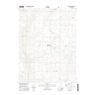
2016 Map of Deadman Park
USGS Topo · Published 2016About this map
Roosevelt National Forest dominates this high-country landscape, where a sophisticated network of irrigation ditches and forest roads reveals the area's dual roles in water management and timber research. The terrain is defined by prominent elevations such as Deadman Hill and Little Bald Mtn, which overlook a complex hydrology including Sand Cr, Deadman Cr, and the Fork Cache La Poudre River. The presence of the Deadman Experimental forest area and the Deadman Lookout indicates a long history of resource monitoring and fire management. Significant water engineering projects are visible through the Columbine Ditch, Eaton Ditch, and Davy Ditch, which redirect flow across the ridges. Lower-lying features like the Nunn Creek Basin provide geographical contrast to the high ridges of Green Ridge and Mid Mtn, while the Roaring Creek Trail suggests historical access for recreation and transit through this mountain environment.
Find a feature on this map
35 named features on this map. Tap any name to fly to it.
Don’t see what you’re looking for? This feature index may not catch every label — zoom into the map to look around manually.
Map Details
Editions of this 2016 Deadman Park Map
This is the sole edition of this map. No revisions or reprints were ever made.
Other maps of this area

1916 · Home
USGS Topo · 1:125,000

1920 · Home
USGS Topo · 1:125,000

1954 · Greeley
USGS Topo · 1:250,000

1957 · Greeley
USGS Topo · 1:250,000

1958 · Greeley
USGS Topo · 1:250,000

1961 · Greeley
USGS Topo · 1:250,000

1962 · Boston Peak
USGS Topo · 1:24,000

1962 · Kinikinik
USGS Topo · 1:24,000
1962 · Rawah Lakes
USGS Topo · 1:24,000

1964 · Greeley
USGS Topo · 1:250,000