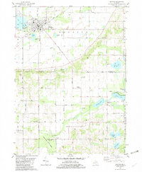
1981 Map of Decatur
USGS Topo · Published 1982About this map
Decatur serves as the primary hub in this southwestern Michigan landscape, where the Amtrak line cuts through the town center near Harrison Cem and the local High Sch. The geography transitions from the residential and municipal grid of the village to a dense network of glacial lakes and wetlands to the south and east. Significant water bodies like Lake of the Woods and Finch Lake are surrounded by a patchwork of agricultural land and managed woodlands, including the Fred Russ State Forest near Volinia. The map documents numerous rural markers of the early 1980s, from the Decatur Bible Ch and First Baptist Ch to the small settlement at Nicholsville near Bunker Lake. Small-scale industrial activity is evidenced by scattered sandpits and gravel pits, while the local infrastructure is further detailed by the Landing Strip and Radio Tower east of town.
Find a feature on this map
64 named features on this map. Tap any name to fly to it.
Don’t see what you’re looking for? This feature index may not catch every label — zoom into the map to look around manually.
Map Details
Editions of this 1981 Decatur Map
This is the sole edition of this map. No revisions or reprints were ever made.
Other maps of this area

1927 · Hartford
USGS Topo · 1:62,500

1931 · Hartford
USGS Topo · 1:62,500

1944 · Marcellus
USGS Topo · 1:62,500

1945 · Cassopolis
USGS Topo · 1:62,500

1946 · Marcellus
USGS Topo · 1:62,500

1947 · Cassopolis
USGS Topo · 1:62,500

1948 · Vandalia
USGS Topo · 1:62,500

1949 · Vandalia
USGS Topo · 1:62,500

1953 · Fort Wayne
USGS Topo · 1:250,000

1953 · Chicago
USGS Topo · 1:250,000