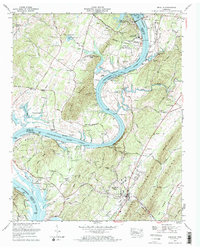
1973 Map of Decatur
USGS Topo · Published 1976About this map
Watts Bar Dam and the adjacent power infrastructure define this 1970s landscape along the Tennessee River. The sheet captures a significant industrial transition with the Watts Bar Nuclear Plant noted as under construction, alongside the established Watts Bar Steam Plant. In the river valley below, the Watts Bar Lake and Chickamauga Lake reservoirs create a complex shoreline of bends and sloughs, including McDonald Bend and Smith Bend. The town of Decatur serves as a central hub, surrounded by family-named landmarks and historical sites like the Indian mound near Cooke Landing. Genealogists will find a high density of small burial grounds, such as Porter-Ward Cem, Smith-Wilkey Cem, and Old Goodfield Cem, reflecting the deep-rooted settlement patterns of Meigs County before and after the TVA river management projects.
Find a feature on this map
81 named features on this map. Tap any name to fly to it.
Don’t see what you’re looking for? This feature index may not catch every label — zoom into the map to look around manually.
Map Details
Editions of this 1973 Decatur Map
2 editions found
Other maps of this area

1886 · Cleveland
USGS Topo · 1:125,000

1887 · Kingston
USGS Topo · 1:125,000

1891 · Kingston
USGS Topo · 1:125,000

1892 · Cleveland
USGS Topo · 1:125,000

1893 · Kingston
USGS Topo · 1:125,000

1895 · Cleveland
USGS Topo · 1:125,000

1901 · Cleveland
USGS Topo · 1:125,000

1935 · Goodfield
USGS Topo · 1:24,000

1935 · Evensville
USGS Topo · 1:24,000

1935 · Decatur
USGS Topo · 1:24,000