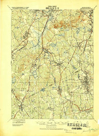
1919 Map of Dedham
USGS Topo · Published 1919About this map
Blue Hills Reservation dominates the northeastern landscape of this military survey, anchoring a region defined by granite peaks like Great Blue Hill and Chickatawbut Hill. The surrounding towns of Dedham, Canton, and Stoughton are shown at a high point of rail-based industrial expansion. The complex trackage of the New York New Haven and Hartford RR and the Old Colony RR crisscrosses the terrain, establishing vital hubs at Canton Junction and Readville.
Find a feature on this map
106 named features on this map. Tap any name to fly to it.
Don’t see what you’re looking for? This feature index may not catch every label — zoom into the map to look around manually.
Map Details
Editions of this 1919 Dedham Map
This is the sole edition of this map. No revisions or reprints were ever made.
Other maps of this area

1885 · Abington
USGS Topo · 1:62,500

1885 · Middleboro
USGS Topo · 1:62,500

1885 · Taunton
USGS Topo · 1:62,500

1886 · Dedham
USGS Topo · 1:62,500

1886 · Framingham
USGS Topo · 1:62,500

1887 · Franklin
USGS Topo · 1:62,500

1887 · Providence
USGS Topo · 1:62,500

1888 · Taunton
USGS Topo · 1:62,500
1888 · Middleboro
USGS Topo · 1:62,500
1888 · Abington
USGS Topo · 1:62,500