
1977 Map of Deep Creek
USGS Topo · Published 1986About this map
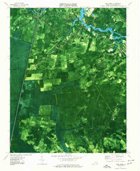
The Great Dismal Swamp National Wildlife Refuge dominates the western portion of this landscape, its boundary defined by a series of straight-line drainage features like Rosemary Ditch and Northeast Ditch. The transition from the dense swamp to the agricultural and suburbanizing areas of Chesapeake reveals a mid-century community in flux. Significant transportation corridors, including the George Washington Canal (Intracoastal Waterway) and the Norfolk and Western Railroad, support the region's movement of goods. Along the Southern Branch Elizabeth River, sites like Bells Mill and Camp Young indicate historical industry and gathering places. Local life is centered around institutions such as Faith Hope and Charity No 2 Ch and Tidewater Community College, while the Chesapeake Municipal Airport marks the era's infrastructure development.
Find a feature on this map
45 named features on this map. Tap any name to fly to it.
Don’t see what you’re looking for? This feature index may not catch every label — zoom into the map to look around manually.
Map Details
Editions of this 1977 Deep Creek Map
2 editions found
Historical Maps of Chesapeake Through Time
85 maps found

1907 Norfolk
Virginia

1916 Back Bay
Virginia

1918 Cape Henry
Virginia

1919 Cape Henry
Virginia

1919 Suffolk
Virginia

1931 Rural Retreat
Virginia

1935 Charlottesville And Vicinity
Virginia

1940 Lake Drummond
Virginia

1943 Back Bay
Virginia

1944 Hampton
Virginia

1944 Norfolk South
Virginia

1945 Lake Drummond
Virginia

1948 Kempsville
Virginia

1948 Norfolk North
Virginia

1948 Norfolk South
Virginia

1948 Ocean View
Virginia

1948 Princess Anne
Virginia

1948 Virginia Beach
Virginia

1952 Bowers Hill
Virginia

1952 Cape Henry
Virginia

1953 North Bay
Virginia

1954 Buckhorn
Virginia

1954 Corapeake
Virginia

1954 Creeds
Virginia

1954 Deep Creek
Virginia

1954 Fentress
Virginia

1954 Knotts Island
Virginia

1954 Lake Drummond
Virginia

1954 Lake Drummond NW
Virginia

1954 Lake Drummond SE
Virginia

1954 Ocean View
Virginia

1954 Pleasant Ridge
Virginia

1954 Suffolk
Virginia

1954 Suffolk
Virginia

1955 Bowers Hill
Virginia

1955 Cape Henry
Virginia

1955 Hampton
Virginia

1955 Kempsville
Virginia

1955 Norfolk North
Virginia

1955 Norfolk South
Virginia

1955 Princess Anne
Virginia

1955 Virginia Beach
Virginia

1960 Charlottesville And Vicinity
Virginia

1964 Cape Henry
Virginia

1964 Little Creek
Virginia

1965 Bowers Hill
Virginia

1965 Hampton
Virginia

1965 Kempsville
Virginia

1965 Norfolk North
Virginia

1965 Norfolk South
Virginia

1965 Princess Anne
Virginia

1965 Virginia Beach
Virginia

1967 Whaleyville
Virginia

1973 Hampton
Virginia

1977 Corapeake
Virginia

1977 Creeds
Virginia
1977 Deep Creek
Virginia

1977 Lake Drummond
Virginia

1977 Lake Drummond NW
Virginia

1977 Lake Drummond SE
Virginia

1977 Suffolk
Virginia

1994 Bowers Hill
Virginia

1994 Kempsville
Virginia

1994 Norfolk South
Virginia

1997 Suffolk
Virginia

2022 Bowers Hill
Virginia

2022 Buckhorn
Virginia

2022 Cape Henry
Virginia

2022 Creeds
Virginia

2022 Deep Creek
Virginia

2022 Fentress
Virginia

2022 Hampton
Virginia

2022 Lake Drummond
Virginia

2022 Lake Drummond NW
Virginia

2022 Lake Drummond SE
Virginia

2022 Little Creek
Virginia

2022 Norfolk North
Virginia

2022 Norfolk South
Virginia

2022 North Bay
Virginia

2022 Pleasant Ridge
Virginia

2022 Princess Anne
Virginia

2022 Suffolk
Virginia

2022 Virginia Beach
Virginia

2022 Whaleyville
Virginia

2023 Kempsville
Virginia