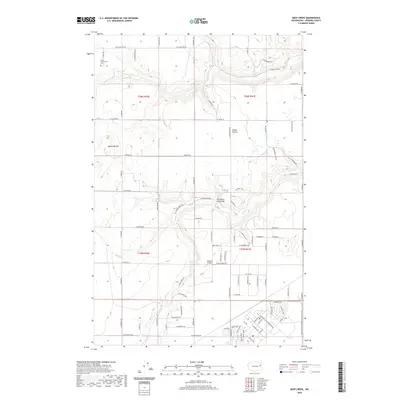
2020 Map of Deep Creek
USGS Topo · Published 2020About this map
Indian Prairie and the undulating terrain of northwestern Spokane County are defined by the convergence of several waterways, including Coulee Cr and the winding Deep Cr. This 2020 landscape reveals a patchwork of rural homesteads and agricultural allotments organized along a network of numbered and family-named roads such as W Coulee Hite Rd and N Burnett Rd. Local history and infrastructure are represented by the West Greenwood Cem in the northwest and the Isaacson Airport situated near the center of the sheet. The southern edge of the quadrangle shows increased development, where the Burlington Northern Santa Fe Railway runs parallel to established transit corridors. Significant landmarks like McDowell Hill and the Christensen Road Bridge provide clear points of reference for navigating this portion of the Inland Northwest's high prairie country.
Find a feature on this map
120 named features on this map. Tap any name to fly to it.
Don’t see what you’re looking for? This feature index may not catch every label — zoom into the map to look around manually.
Map Details
Editions of this 2020 Deep Creek Map
This is the sole edition of this map. No revisions or reprints were ever made.
Other maps of this area
1943 · Medical Lake
USGS Topo · 1:62,500
1944 · Clayton
USGS Topo · 1:62,500
1944 · Wellpinit
USGS Topo · 1:62,500
1945 · Reardan
USGS Topo · 1:62,500
1950 · Clayton
USGS Topo · 1:62,500
1953 · Reardan
USGS Topo · 1:62,500
1953 · Wellpinit
USGS Topo · 1:62,500
1954 · Airway Heights
USGS Topo · 1:24,000
1954 · Medical Lake
USGS Topo · 1:24,000
1954 · Medical Lake
USGS Topo · 1:62,500