
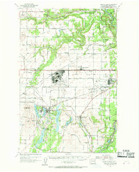
1954 Map of Medical Lake
USGS Topo · Published 1956About this map
The massive Fairchild Air Force Base footprint dominates the center of this mid-century landscape, illustrating the Cold War military expansion southwest of Spokane. This strategic hub is flanked by Geiger Field and the Deep Creek Air Force Station, reflecting the area's intensive aviation and defense roles during the 1950s. The surrounding terrain is a mix of basalt plateaus like Indian Prairie and a chain of glacial water bodies including Silver Lake, Medical Lake, and Clear Lake.
Find a feature on this map
73 named features on this map. Tap any name to fly to it.
Don’t see what you’re looking for? This feature index may not catch every label — zoom into the map to look around manually.
Map Details
Editions of this 1954 Medical Lake Map
2 editions found
Other maps of this area

1901 · Spokane
USGS Topo · 1:125,000

1903 · Oakesdale
USGS Topo · 1:125,000

1905 · Oakesdale
USGS Topo · 1:125,000

1943 · Medical Lake
USGS Topo · 1:62,500

1944 · Clayton
USGS Topo · 1:62,500

1944 · Wellpinit
USGS Topo · 1:62,500

1945 · Reardan
USGS Topo · 1:62,500

1949 · Deer Park
USGS Topo · 1:62,500

1950 · Spokane SW
USGS Topo · 1:24,000

1950 · Spokane NW
USGS Topo · 1:24,000