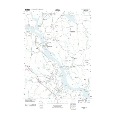
2012 Map of Deep River
USGS Topo · Published 2012About this map
The Connecticut River serves as the central artery for this portion of the Lower Connecticut River Valley, defining the boundaries and economic life of settlements like East Haddam, Chester, and Deep River. This modern survey details the persistent maritime and industrial heritage of the region, from the Warners Quarry Dock on the western bank to the Goodspeeds Landing and the iconic East Haddam Bridge. The landscape is dotted with numerous ancestral sites, including the Old Cove Burying Ground near Graveyard Point and the Mount Parnassus Burying Ground to the east. The rail corridor of the Valley RR follows the western shoreline, connecting the riverfront communities. Notable inland features such as Mount Parnassus and Rattlesnake Ledges overlook a complex network of tributaries like Moodus River and Whalebone Creek, which have historically powered local industry and provided natural harbors like Deep River Cove.
Find a feature on this map
240 named features on this map. Tap any name to fly to it.
Don’t see what you’re looking for? This feature index may not catch every label — zoom into the map to look around manually.
Map Details
Editions of this 2012 Deep River Map
This is the sole edition of this map. No revisions or reprints were ever made.
Other maps of this area

1892 · Gilead
USGS Topo · 1:62,500

1893 · Guilford
USGS Topo · 1:62,500

1893 · Middletown
USGS Topo · 1:62,500

1893 · Saybrook
USGS Topo · 1:62,500

1906 · Farmington
USGS Topo · 1:125,000

1941 · Lyme
USGS Topo · 1:31,680

1944 · Essex
USGS Topo · 1:31,680

1944 · Deep River
USGS Topo · 1:31,680

1945 · Middle Haddam
USGS Topo · 1:31,680
1945 · Colchester
USGS Topo · 1:31,680